
TL;DR – Today we chart out the Civilization VI City List in Map form
Article –
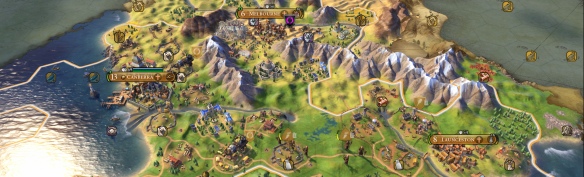
So today I continue with my Map-It series by following up on our Civilization Map-It project by this time looking at the city lists of each civ. It was originally my aim to have all the cities on the big map, but after trying that out with just America it quickly became apparent that it would be hard to read and would clutter an already full map, and this is not taking into account the same city might appear on many different city lists. However, after a while I continued to want to see how the city lists come together and how they play out in geographical space so I decided you didn’t need to put them all on the one map, I could create an individual map for each civilization. Now naïvely I just assumed that I could just cut out the civilization maps from my big map, do a little touch up in places and go for it. Well … that was not the case, with most maps needing to be recreated from the ground up. Now pf course past me was a real pain for present me, but the lure of maps was too strong so here we are with every civilization’s city lists mapped out. Now before we start, I just want to point out that these city locations are not meant to be pinpoint accurate, the groupings and questionable locations of some cities make that impossible. Just think of this more of a general guide of where they are located. Also for our mobile guests, there will be a lot of images incoming, so even though I have tried to keep them small, now would be a good time to check that you are using wi-fi and not data
America City Map

America is an interesting map, because with a county the size (both geographically and demographically) it is not the case of which cities you pick but where do you draw the line. So we get some interesting omissions (nothing from Alaska or Hawaii) but we also get Puerto Rico on the map for the first time, also a little Sparks Easter Egg.
Arabia City Map

So with Arabia, it is a good time to remind everyone that the civilization borders we have on all these maps are based on the leader Firaxis chose to represent them. This is important with Arabia because which leader you pick will dramatically shift the focus of the civilization from Mecca, to Medina, to Baghdad, to in this case Cairo. Even with this focus, the Arabia city list focuses heavily on modern Syria and the surrounding area, with names that have unfortunately become quite familiar of the last few years. Two quick notes on this map, there were two equally valid choices when it came to Tripoli (Modern Libya and Lebanon), so I added both. As well as this, as far as I can tell Aleppo and Halab are the same city, if I’m wrong there could you let me know.
Australia City Map

Now I would be lying if I didn’t say I am still so incredibly chuffed that Australia got added to the game. Not only was it added, but the developers at Firaxis showed that they put a lot of effort into crafting a civ that really did reflect the time period they choose. Now if I was being picky, and this is the only time I really can, Launceston is way too high on the list while Darwin is too low, and I would have given Broome some love and this is even with my hometown not being on the list. What the cities do show is the reflection of the Australian population with 85-95% of the population living along the coastline and most along the east from Cains to Adelaide, and it is really cool to see that shown in the map. Now one quick thing, all names of cities are pulled right from the game’s data and displayed as they appear here, and it is clear that in this rendition that the developers often went with more old-fashioned spellings of cities names, which we can see here with Ballaarat (Ballarat).
Aztec City Map

Now This is not the first time I have attempted a project like this, back during the Civ 5 days I was putting something together for Civfanatics which ended up not going anywhere. However, the one thing I can remember from that time was just how much of a pain putting together the Aztec map was given how little information there was. However, thankfully this time around it was a much easier undertaking because I was able to access two maps that gave pretty good locations for most of the cities on the list. The one thing that came really clear about halfway into making this map is that there would have to be an insert added as the Valley of Mexico section is so crowded which is to be expected given power and distribution of the Aztec Empire. Also interesting because most of those lakes just don’t exist anymore having being drained to make way for the growing Mexico City.
Brazil City Map

Brazil was the first map I put together when I was constructing this project and as far as some of these other maps go it was relatively straightforward. Mostly because most of the city names are either the same in modern Brazil or easily identifiable when they have changed. The big difficulty with this map was getting all the cities around Rio de Janeiro and Sao Paulo to fit. Indeed there were multiple times where I would move all the city names around to get them to fit, only to discover I had to add a new city to the area and start all over again. I got better at not getting myself into this situation with other maps, but there were more than a few curses of exasperation when the map honed in on Sao Paulo again.
China City Map

China is one of those odd maps, because it looks nothing like the China we have today as this was the first but one of its many consolidation periods. In many respects this was a difficult map to put together as the developers chose a lot of small old cities that were hard to find references to, as well as this there were a lot of provinces chooses rather than actually cities so that made locating them on the map a difficult prospect. So there are a couple of points on this map that could be moved around depending on how you locate ancient provinces of China.
Egypt City Map

Now, this was the almost the most troublesome map to put together, and the only map I had to scrap after finishing it and rebuild it again from the ground up. There were two issues that didn’t present themselves right away but soon became big issues. The first was how many of the cities were in the Nile River Delta, which was much higher than I expected. The second issue is that in this version Firaxis went with the city names in the original Egyptian written in Roman characters. This meant locating cities that are now in Egyptian Arabic, known more commonly by their Greek translated names, written in Egyptian, for example, Shedet was known more commonly known as Crocodilopolis and is now Faiyum. Both of these led to the first map being a complete write-off, however, not being deterred I went back to the drawing board, and I think Egypt version two might be my favourite map I put together.
England City Map

Ah England, home to the yearly debate as to if the civilization should be called England or Great Brittan, well the city list seems to come down on one side of this particular argument. Now this being said this is probably an example of the city list giving a nod to some upcoming potential civilizations, like Egypt who has a couple of missing cities that ended up in Nubia. Here the lack of cities in Scotland, Wales and Ireland most likely point to the developers at least giving room for a potential Celtic civilization in the future. Also given the English/British had the largest empire the world has ever seen (so far) and the sun still technically does not set on England’s domains, it was interesting to see all the cities located just to England.
France City Map
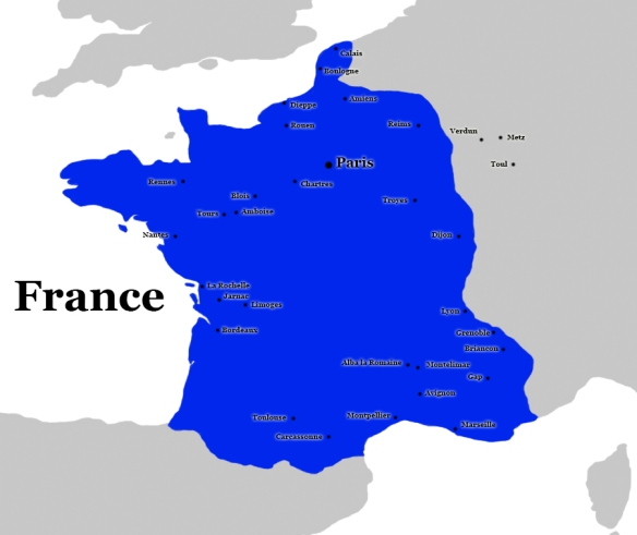
France is one of those interesting civilizations because on the map they are only quite small, not even to the borders of where they are today, but the snapshot of the civilization was taken on the cusp of the country creating an empire. So here we see France being quite localised, and well there is not much else I can say other than I hear the Mediterranean coast is beautiful at this time of year.
Germany City Map

So here with Germany, we get to see a couple of things that are interesting, the first being that for this we are pretending that the Holy Roman Empire was a contiguous political unit, which is a bit funny. However, it is also quite clear that someone on the Firaxis team really likes their reformation history. In the data, Aachen actually appears a bit lower down the list than most capitals, which makes sense, but also possibly gives Germany a good chance of having two leaders coming up.
Greece City Map

Greece was a difficult civilization to get a handle on how to represent. This is because the game has given it two leaders, and it always feels a bit odd to represent collections of independent city-states as a united front. So do you divide Greece between the Delian League and the Peloponnesian League? I eventually went with how they are represented in-game, for sake of integrity, and not in any way because it was the easiest thing to do. Now the international relations part of me really would have liked to see Melos on the list, but we can’t get everything we want. Also, there is a city here Apolyton, that is not actually a city, which is a little odd until you realise it is a little nod to a stalwart of the fan community.
India City Map

Now with India, I should make clear that we are using the de facto political boundaries which are heavily contested by neighbouring countries. We are not arguing that these are correct, just that they reflect the political realities of the time and today. India is another of those civilizations where the choice is now which cities do you pick but how do you limit them to a relatively small list. One of the interesting things about the Indian city list is how it isolated between old and new spellings for cities names throughout.
Indonesia City Map

Well out of every civilization that I have worked on so far I think Indonesia wins the prize for having the most diverse differences between different maps. Nearly every map I consulted had a different territorial outlook for the then Majapahit Empire. This is compounded by Dyah Gitarja (or Tribhuwannottunggadewi Jayawishnuwardhani to her friends) abdicating so we can’t get a good end date as there may have been some overlap with the next king Hayam Wuruk and the Prime Minister Gajah Mada. From my research, the difference lies in how generally you take the accounts of Gajah Mada and his conquest for the Queen. After a lot of searching, I eventually went with EmperorTigerstar’s estimates as a good guide. While there were a lot of issues getting the borders right, when it came to the cities list it was almost the reverse with Indonesia being one of the easiest civilizations to find information as to where the cities are. The only things is, well the International Relations side of me would have loved to see Bandung on the city list, but oh well.
Japan City Map

Now with Japan, there is not much to say as the city list it quite straightforward. However, if I could say one thing, it would that I really want to visit Japan again at some point, like really want to, there is a drive there to make it happen.
Khmer City Map

With Khmer, we were given a very interesting dilemma as to how best to represent its political borders. Of all the maps I looked at about half listed Champa (the area around modern southern Vietnam) as part of Khmers, domains at the time and half had it as its own country. Doing some research I found that the area had been recently annexed by Jayavarman VII, which probably led to the divide. I eventually went with those who had it as part of the Khmer empire when I found out that the capital of Champa was on the Khmer city list, which seemed to settle the argument. As well as this, it became pretty clear quite early on in making this map that I would need to have an inset map for the Angkor area. I think Khmer overtook the Aztecs in having the most cities in on a small area, coincidently also near a lake. Also, a couple of cities we are not completely sure of their locations, so I used the best guesses of archaeologists when putting them on the map.
Kongo City Map

So when I was about two-thirds of the way through this project I found that internet user LacsiraxAriscal had done a similar mapping project using Google Maps. Now I powered on because I was doing something a bit different here but it was good to see I was not the only one who struggled with Kongo’s city placement. Oh, boy was this map a struggle to put together, it takes the cake as the longest map I worked on, and that includes Egypt which I did twice. So unlike other maps, this is the one with the most potential inaccuracies because there was little information for some cities and far too many options for others, so at some point, you just have to make an educated guess. I thought my Google-fu was strong, but alas I came across an opponent that was better than me.
Macedon City Map
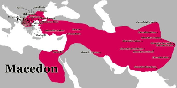
The Macedon civilization is a really interesting one as we mentioned in our review as it fits across two worlds. This is something we also see in the city list, which on the one hand is clustered around that northern Greece and then all the Alexandrias across modern Afghanistan and Pakistan. Now some of these Alexandrias are still not completely confirmed as to their locations so I had to take the best guesses of the possible sites presented by classical scholars. However, this divide does lead to the most interesting of the many maps, and sheds an interesting light on Alexandria himself.
Norway City Map
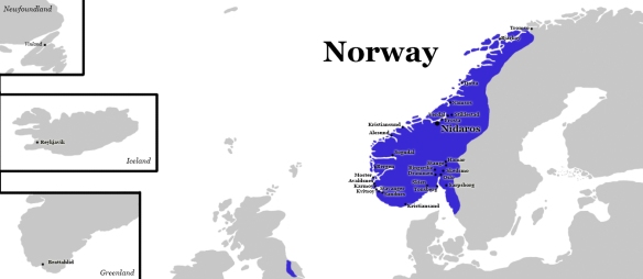
The Norway civilization map was an interesting one to put together because there was a lot of debate as to what was Norway, Denmark & Sweden during this time. Should you include all of the assorted Viking settlements at the time in Norway’s territory, or just Norway proper, as many of those territories were held by Denmark but not. Eventually, as there is still a chance Denmark might make an appearance I went with just the core of Norway, which on the whole is supported by the cities Firaxis chose. Now, of course, there is one possible are in contention and that is with Vinland. Was Vinland a single settlement, was it the name for a region, or was it just a generic name for the type of terrain the Vikings found in North America, we simply don’t know, thanks contradicting Icelandic sagas. However, I have put Vinland in one of the more probable locations, even though we can’t know for certain.
Nubia City Map

Nubia was one map I was surprised with how easily it came together, with a lot of the ancient civilizations the city locations are a bit all over the place unless they have had extensive excavations. However, with Nubia, the records were actually quite easy to find and determine a location, made a lot easier by most of the cities being on the Nile. The one city I did find hard to place was Shaat, I found a lot of references to existing, it but not to where it was until I found reference to the island of Sai and there it was. Another thing I found was just how many cities from Nubia and the upper Kingdom that were flooded by the Aswan Dam, it was quite surprising.
Persia City Map

With Persia, there were a couple of interesting things I noticed when putting the city list together. The first thing is that as far as I can tell Parsa and Pasargadae were the same cities now if I am wrong here please let me know in the comments below. The other was that Persia and Rome (see below) look to give us the indication that Armenia won’t be in the game as a civilization, at least not in the short term. With a lot of city lists we see a clear gap made for some of the new civilizations that have come and ones we expect to see, but with key cities from Armenia appearing in multiple lists and with Yerevan being a city-state it looks quite clear. However, Armenia is a fascinating civilization so I’d be more than happy to be found wrong here.
Poland City Map

Poland was always one of the more difficult civilizations to map out, because there was a lot of disagreement as to just where its borders should be during this time period. Do you include Lithuania as well, what about the Teutonic Order, and so on. In the end, I went with more of a compromise border than I did for the others, and you can see that difference in how the cities map out compared to the territory.
Rome City Map

Rome was an interesting civilization to map out their cities because there are clearly gaps for not one but two possible future civilizations. Along the African coast where you would expect to see cities like Hippo Regius there is a clear absence of anything, the same for around Thrace region with no Byzantium/Constantinople or is it Istanbul. While this could all just be conjecture, it really is striking once you map it out and I think it does show a pattern.
Russia City Map

Russia was an interesting civilization, in that I was not expecting it to be as concentrated in and around Moscow as it ended up being. Yes I know that is where the population is concentrated but quite often people like to emphasise the expanse of Russia by showing the width of cities that they have, but it’s not the case here, sort of. Maybe I’m just annoyed that we got Omsk over Vladivostok.
Scythians City Map

The Scythians map was another map to put together for a number of reasons, the first of which is the territory. Historically the Scythian people have moved quite a bit as they migrated across the steps of Central Asia. Now while most of the Scythian settlements are concentrated around the Black Sea, historically they stretch much further. This is compounded by the choice of capital, which could be in two possible locations, but both far away from the core. The second issue was locating many of the city locations across the Black Sea area. In most cases, these cities were royal kurgans, or burial mounds (also their unique map improvement in the game), and while I could find the general locations, I could not get it as precise as I wanted. I was saved by an article written about the analysis of two horse skeletons that were dug up when excavating a kurgan and lo it have a full map. So thank you to those osteoarchaeologists for making my life easier.
Spain City Map
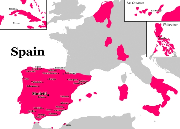
Spain is an interesting civilization with regards, to its cities, because at the time of writing, they are the most spread out of any civilization. Not only do we get the core of, we also get cities in Cuba, the Canary Islands, and the Philippines. So far other than Norway they are the only civilization that shows the extent of their empire through the city list. Though once again, no cities in both Portugal and the Netherlands, once again hinting maybe of future potential civilizations.
Sumeria City Map
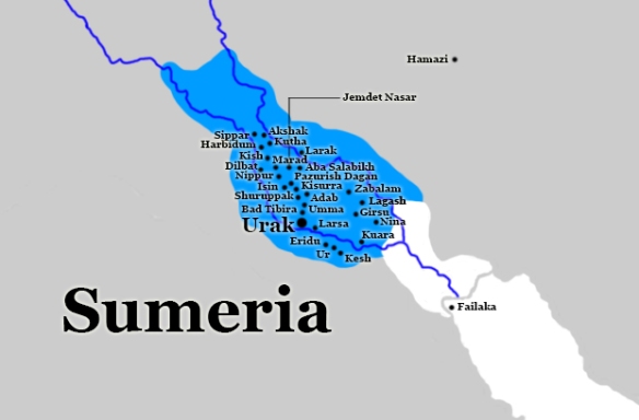
Our final civilization at the time of writing is also the smallest with regards to land area and this is Sumeria or Sumer as it is sometimes called. Now like some of the other ancient civilizations some of the cities might not be exact, but you will notice they follow certain lines across the landscape, these were ancient channels which would have been easier to regulate than the great Tigris and Euphrates rivers. Another quirk with this map is that at the time of Sumeria the coastline was actually much further inland than it is today. We’ve added the coastline but also have left the modern coastline and river course for reference.
So there we have it all the current civilizations city lists mapped out, I hope you enjoyed it or at least found it interesting, and we will update it as more DLC and Expansion packs get added.
By Brian MacNamara: You can follow Brian on Twitter Here, when he’s not chatting about Movies and TV, he’ll be talking about International Relations, or the Solar System.
Have you seen any odd maps in Movies, TV or Video Games?, let us know in the comments below, feel free to share this review on any of the social medias and you can follow us Here. Check out all our past reviews and articles Here, and have a happy day.
Credits –
- The World Map that we used was created by ‘San Jose’ which is shared with a Creative Commons Licence
- The Africa Map we used was created by ‘Eric Gaba’ which is shared with a Creative Commons Licence
- The Basin of Mexico Map we used was created by ‘Yavidaxiu’ which is shared with a Creative Commons Licence
- The Aztec Empire Map we used was created by ‘Giggette’ which is shared with a Creative Commons Licence
- The West Asia Map we used was created by ‘Shinas’ and is within the Public Domain
- The British Isles Map we used was created by ‘Cnbrb’ and is within the Public Domain
- The Japan Map we used was created by ‘WiJG?’ and is within the Public Domain
- The Europe Map we used was created by ‘Ijanderson’ and is within the Public Domain
- The South East Asia Map we used was created by ‘Sylvanmoon‘ and is within the Public Domain
Lead Designer – Ed Beach
Lead Engineer – Ken Grey
Producers – Dennis Shirk & Sarah Darney
Art Director – Brian Busatti
Music – Geoff Knorr, Phill Boucher, Roland Rizzo & Christopher Tin
Developer – Firaxis Games
Publisher – 2K
Disclosure – I am a moderator on the site Civfanatics of which several staff and players are members of the ‘Frankenstein Testing Group’, Firaxis Games internal playtesting team. I am not part of this team nor do I have any links with Firaxis Games or 2K.

In response to your question Pasargadae was the capital under Cyrus. Darius built Parsa (Persepolis) later.
LikeLiked by 1 person
ah good to know
LikeLike
Pingback: Map-It: Civilization VI (Base Game up to the South East Asia DLC) | TL;DR Movie Reviews and Analysis
Pingback: How well did they create Indonesia and Khmer in Civilization VI? | TL;DR Movie Reviews and Analysis
Hey, great maps! You should post them on /r/civ if you haven’t already. Glad to hear you struggled as much with Kongo as I did, hahahaha. Oh, and I’d love to see that Scythia map if you’ve got it to hand – would be great to double check some of the more desperate guesses! Only two little things I saw – you missed a Russian city, one that’s all the way up in northeast Siberia and I have NO idea why Firaxis included. And the other is Indrapura – it’s actually an old Khmer capital that just happens to share its name with the Cham capital. Its location, annoyingly, is unknown.
LikeLike
Hi, I’m glad you liked it, I think I have posted it to the reddit, but you are welcome to do it again if you like.
Hmmm, with Russia I have Nizhnekolymsk down near Kazan, I’ll have to go check my notes as to why I put it down there.
With Khmer, I went the the Champa capital, because it fitted more with the Civ leader which is what I did when there was two similar cities on offer.
I found the map in – Wentz, R. K. and de Grummond, N. T. (2009), Life on horseback: palaeopathology of two Scythian skeletons from Alexandropol, Ukraine. Int. J. Osteoarchaeol., 19: 107–115.
LikeLike
That city appears to be Nizhnekamsk not Nizhnekolymsk, even though that one might make more sense to be included. And fair enough on the Champa front. I just double checked and I was wrong on one part – Indrapura (the older one) is known and is near Kampong Cham, weirdly enough!
Thanks for the map link, I’ll look through that! 🙂
LikeLiked by 1 person
Pingback: Map-It: Civilization VI: Rise and Fall Expansion | TL;DR Movie Reviews and Analysis
Pingback: Map-It Civilization VI: Rise and Fall Cities | TL;DR Movie Reviews and Analysis
Pingback: Map-It Civilization VI: Full Map | TL;DR Movie Reviews and Analysis
Pingback: Civilization VI Cartographic Educational Database | TL;DR Movie Reviews and Analysis